Subscribe to our mailing list to receive news releases and other materials related to Your email will never be shared or sold and you can opt out at any time.
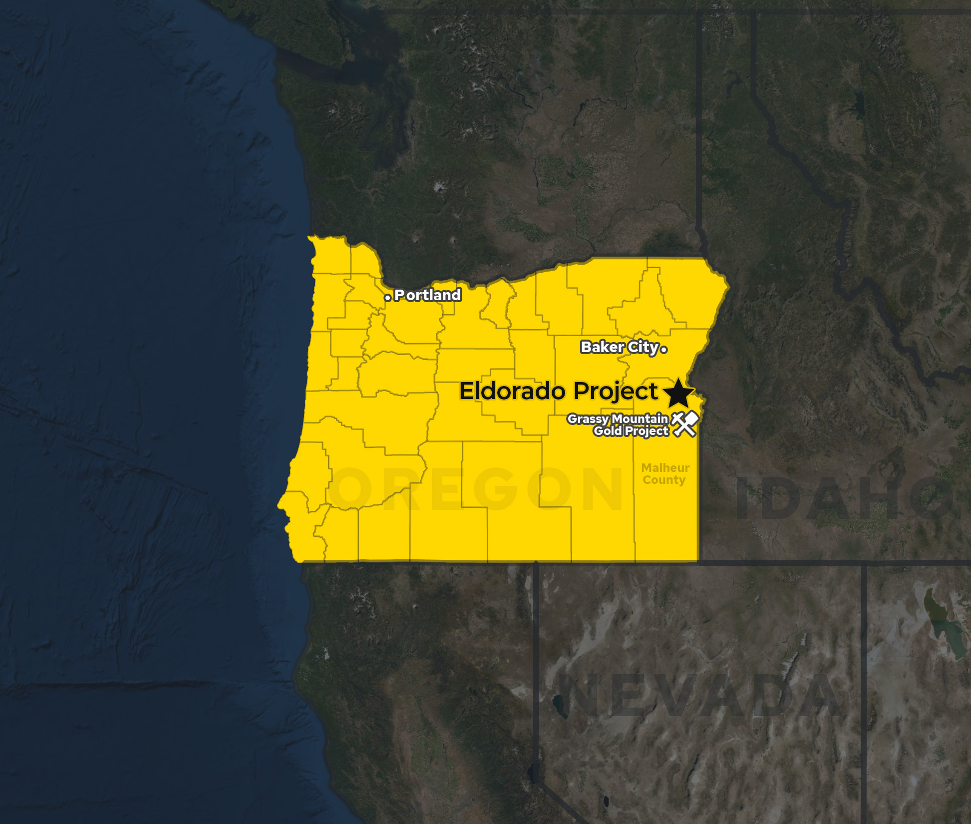
The Eldorado Project is located approximately 60 kilometres (km; 38 miles) northwest of Vale in Malheur County, Oregon. The property hosts a pre-43-101 non-compliant resource estimate of 1.98M oz at 0.753 g/t gold*. The large-scale surface mineralized system remains open in all directions.
*In 1990, the first historical estimate was calculated on what is now the Eldorado Project by Pincock, Alan and Holt (PAH), a reputable engineering firm that was used industry wide for this type of work. PAH modeled 158 of the historic drill holes which identified approximately 52,896,000 tons that graded 0.578 g/t gold (0.0169 oz/t gold) at a cut-off grade of 0.274 grams per ton (0.008 oz/t) in the open-ended gold system. A second historical estimate was calculated by ICAN Minerals based on work completed between 1989 and 1997, which identified 1,980,000 ounces of gold grading 0.753 g/t gold (0.022 oz/t gold) within 90,000,000 tonnes. The Company is not treating either estimate as current mineral resources and a qualified person has not done sufficient work to classify these estimates as current mineral resources. The estimates were prepared prior to the enactment of National Instrument 43-101, and the establishment of current CIM (Canadian Institute of Mining, Metallurgy and Petroleum) classification categories and should not be relied upon for investment decisions. The purpose of presenting this information is to show that the Eldorado Project has potential to hold a large mineral inventory. The Company plans to update these historical estimates into a current resource model. Near term work to accomplish this goal includes confirmation drilling by twinning a number of the historic holes, certifying and comparing assays between the old and new holes, validating all historic holes in the field with a GPS and confirming historic metallurgical test results. When the Company is comfortable with these upgrades in compliance, then a new stand-alone current resource can be calculated. Other than these, the Company is not aware of any more recent estimates prepared for the Eldorado Project, nor is it aware of the existence of any technical reports describing the historical estimates.
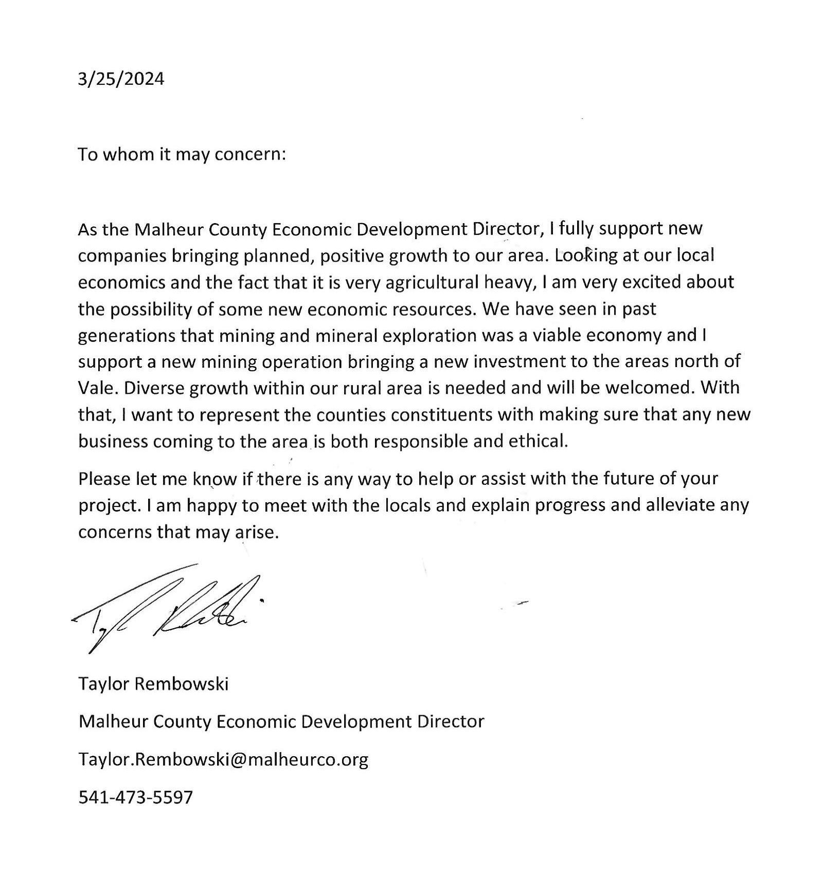
This letter was sent to Provenance and addressed to all readers to show strong local backing for mining activities within Malheur County, Oregon.
A NI 43-101 technical report has been filed for the Eldorado gold property. This historical database is currently not sufficient as the basis for developing a current mineral resource, but work is underway to verify and bring current the historical data.
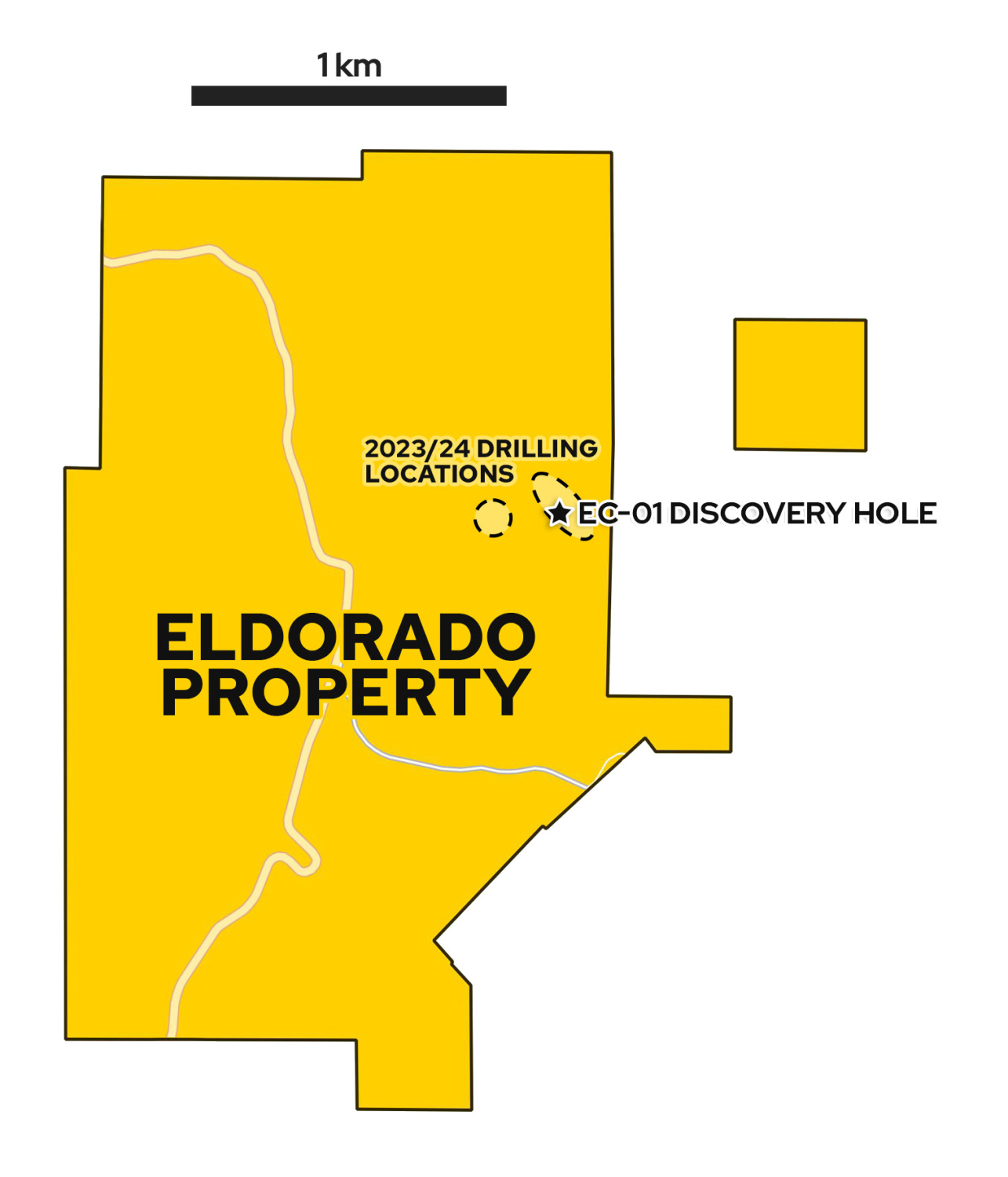
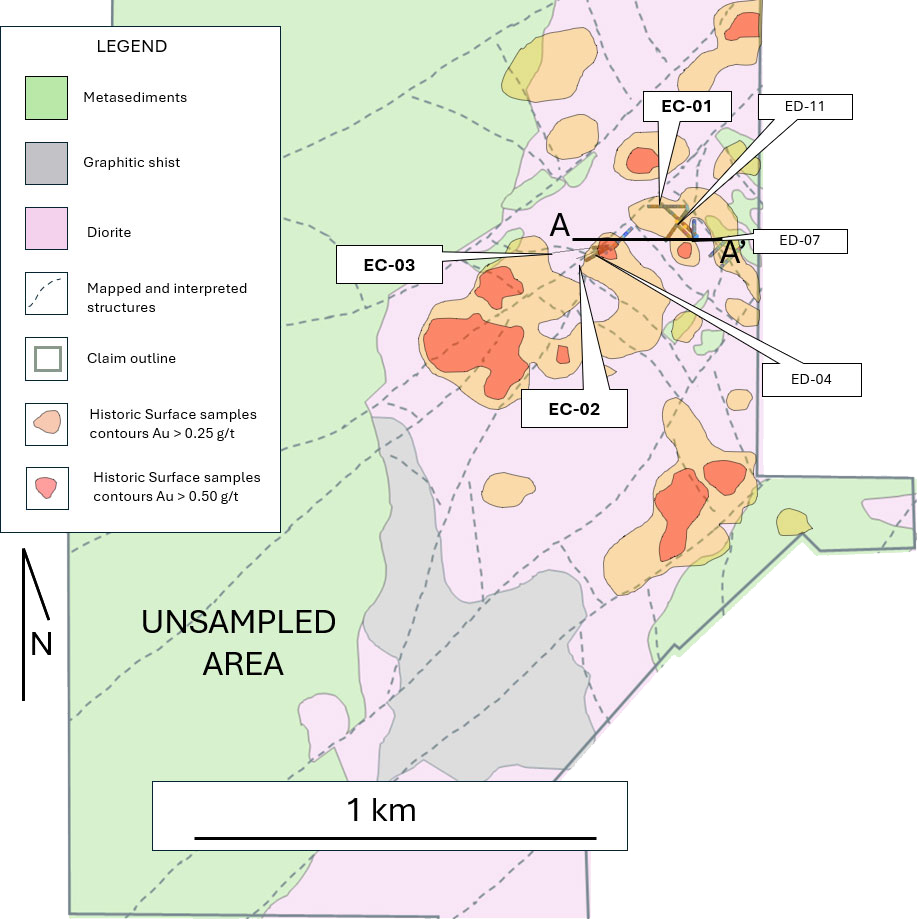
The 1,140-acre land area exhibits evidence of historic placer mining and hosts strong soil gold anomalies as well as scattered widely spaced historic drill holes that report strong gold intervals. Provenance’s geological modeling suggests mineralized structures extend throughout the property, featuring several promising large new target areas outside the confirmed gold system.
Provenance holds a binding option to purchase the property from Nevada Select Royalty Inc., an arms-length subsidiary of Gold Royalty Corp. (NYSE : GROY).
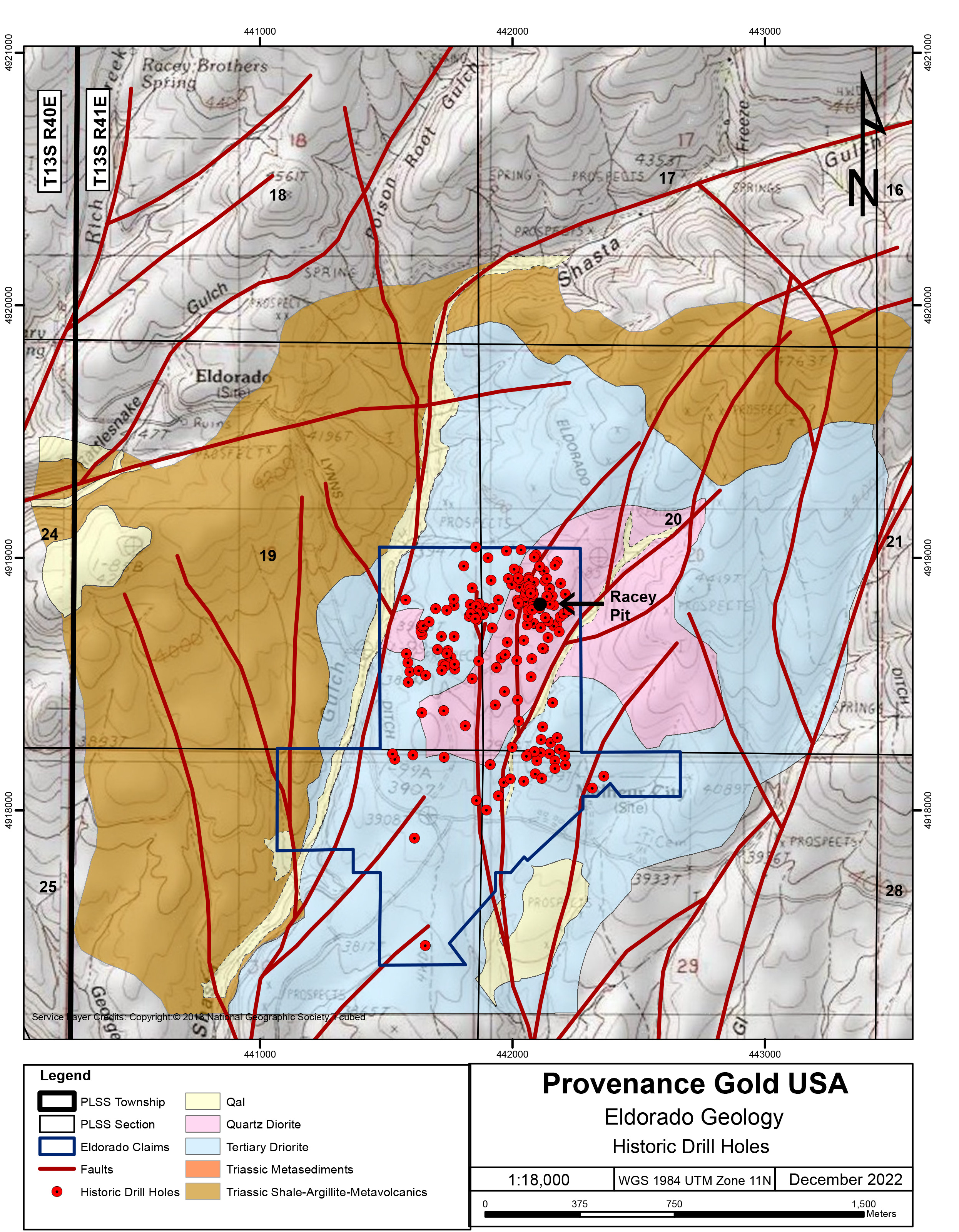
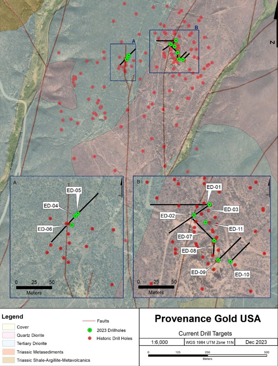
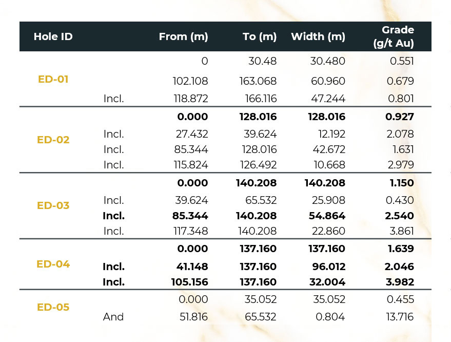
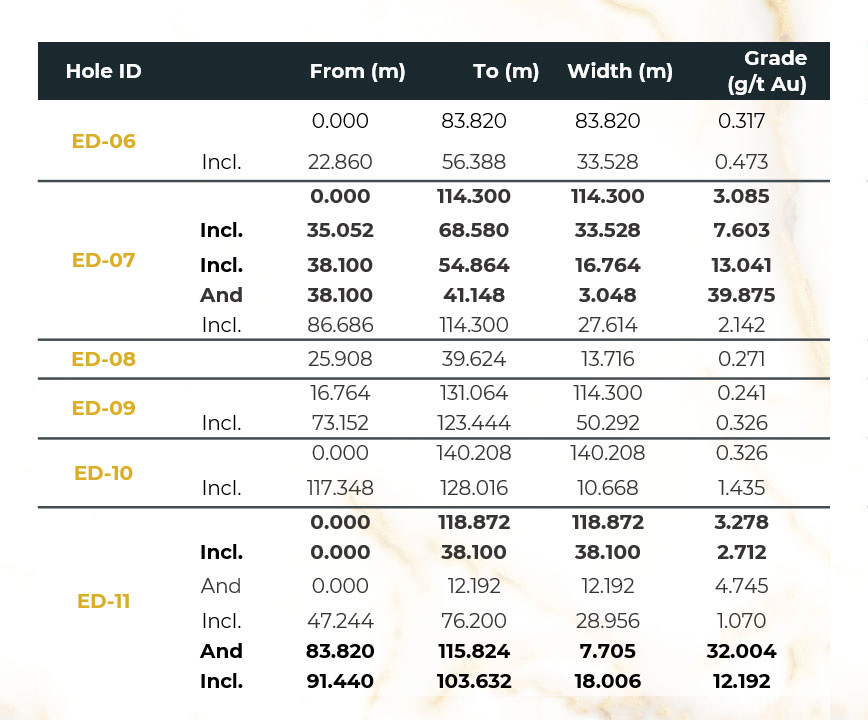
Historic drilling included 236 reverse circulation holes and six core holes totaling 21,867 meters. The latest non-compliant resource estimate, conducted by Ican Minerals in 1997 was 1,980,000 oz gold with 90,000,000 contained tons at a grade of 0.753 g/t gold (0.022 oz/t).
Historic drilling also encountered high-grade breccia zones. These breccia areas are likely complex volcanic pipes and geological structures that host high-grade gold within a large low-medium grade envelope.
The magmatic/hydrothermal mineralization at Eldorado was historically interpreted as a porphyry gold system. It is now interpreted as a much younger epithermal system that utilized the diorite as a host rock. The mineralizing fluids used existing faults and fractures to access and penetrate the diorite. This process resulted in pervasive gold mineralization, with the highest-grade mineralization occurring in and near the plumbing system.
The success of the 2023 drill program, coupled with historic drilling that intersected gold far beyond the 2023 program, would suggest that the mineralized system at Eldorado is large, starts at the surface, extends to depth and remains open in all directions.
| Au Assay (ppm) | ||||
|---|---|---|---|---|
| Sample | Head Direct (50g) | Head Back Calc from test (3kg) | Au Distributed in Grav+Flot Cons (% Recovered) | Comments |
| ED-01 | 0.61 | 1.51 | 46.1 | Oxidized |
| ED-03 | 15.50 | 5.39 | 93.8 | Unoxidized |
| ED-04 | 1.60 | 1.82 | 82.6 | Unoxidized |
| ED-07 | 13.44 | 22.34 | 97.1 | Unoxidized |
| ED-09 | 0.54 | 1.19 | 77.9 | Unoxidized |
| ED-10 | 0.22 | 0.40 | 83.3 | Unoxidized |
| ED-11 | 4.86 | 6.35 | 94.0 | Unoxidized |
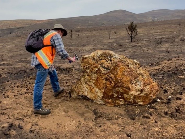
A large wildfire burned off sagebrush and exposed new outcrops and alteration zones which were subsequently mapped, resulting in the discovery of several new impressive step-out zones of mineralization thereby further expanding the already extensive mineralized footprint.
Our newly recognized step-out zones of mineralization extend the recognized mineralization well beyond the area covered by both our drilling and historic drilling. The wildfire also exposed additional areas of historic placer mining activity, and two previously unseen historic prospect pits dug into strongly altered bedrock, all outside historic drilling.
| Hole | From (m) | To (m) | Length (m) | Gold (g/t) | High-Grade Zone |
|---|---|---|---|---|---|
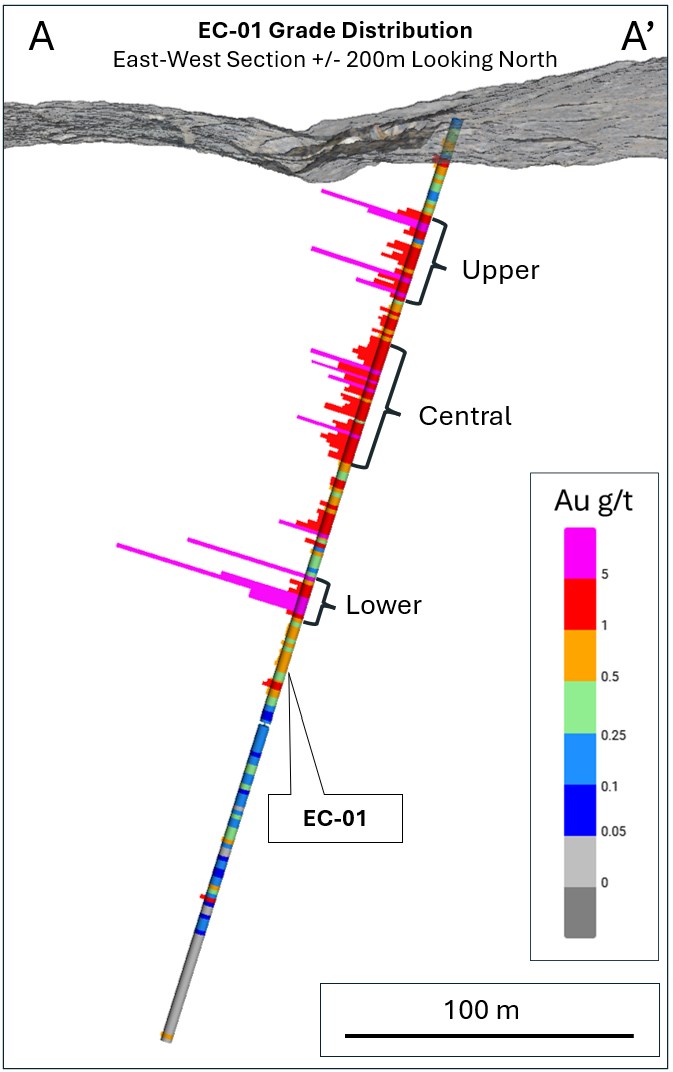
| EC-01 | 0 | 288.34 | 288.34 | 2.01 | |
| Including | 7.92 | 183.18 | 175.26 | 3.07 | |
| And | 34.9 | 65.07 | 30.18 | 4.28 | Upper |
| And | 86.01 | 126.34 | 40.33 | 3.48 | Central |
| And | 167.98 | 181.66 | 13.69 | 13.18 | Lower |
| Including | 175.56 | 181.66 | 6.1 | 21.7 | Lower |
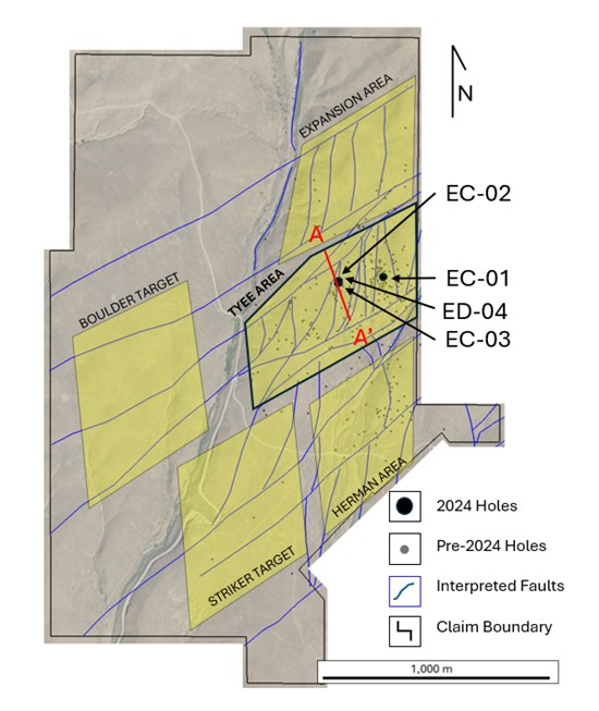
The results from EC-02 and EC-03 are consistent with the presence of the broad mineralized zone found in RC hole ED-04 and support the model that the NE-SW mineralized structure is a significant gold bearing structure, punctuated with multiple higher-grade intervals
| Hole | From (m) | To (m) | Length (m) | Gold (g/t) |
|---|---|---|---|---|
| EC-02 | 0.000 | 156.362 | 156.362 | 0.505 |
| "And" | 32.309 | 64.313 | 32.004 | 0.944 |
| "And" | 84.125 | 96.317 | 12.192 | 1.340 |
| EC-03 | 0.000 | 154.229 | 154.229 | 0.796 |
| "Including" | 53.645 | 154.229 | 100.584 | 1.084 |
| "Including" | 53.645 | 70.805 | 17.160 | 2.080 |
| "And" | 100.889 | 114.605 | 13.716 | 3.021 |
| "Including" | 102.413 | 106.985 | 4.572 | 5.640 |
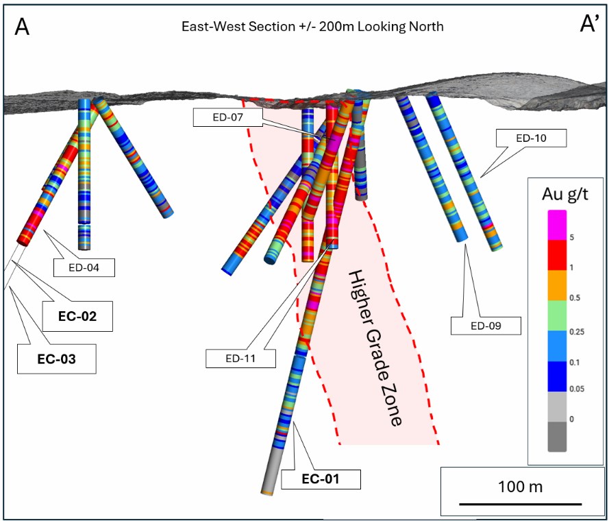
Provenance’s recently completed 698.14 m diamond drill program will allow for analysis of the mineralization’s structural framework and its controls that will guide future programs.
Provenance is planning a 10,000+ meter drill program at Eldorado to commence in early 2025 to confirm and expand the mineralization in historic drill areas and in additional key target areas identified during 2023 and 2024 field work.


Subscribe to our mailing list to receive every Provenance Gold update straight to your inbox. Your email will never be shared or sold and you can cancel your subscription at any time.